Mount Fuji Climbing Guide: Routes, Safety and Official Rules
Choose a summer route, reserve the right support and protect the descent.
- Current status · 2026 season closed
- Route choice · Four summit approaches
- Planning default · Reserved hut overnight
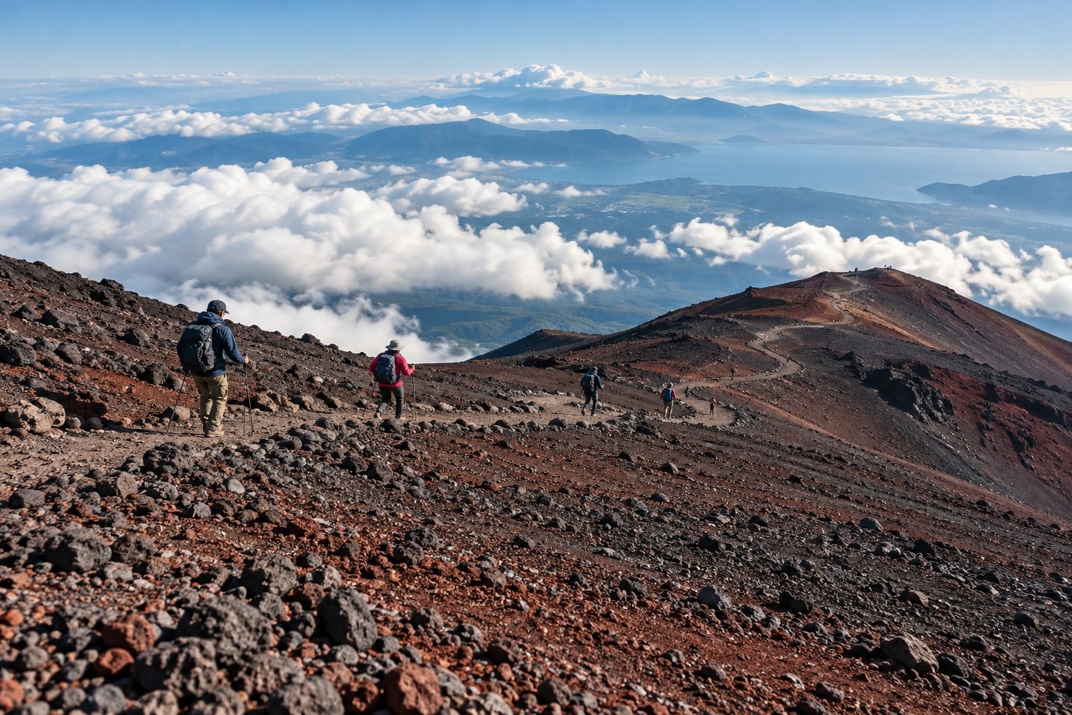
AI-generated editorial illustration inspired by summer hiking on Mount Fuji; terrain and the route are illustrative, not navigation guidance or a documentary photograph.
A Mount Fuji climbing guide should help you decide whether to go before it helps you aim for the summit. Fuji reaches 3,776 m, and the work includes a long descent after a cold, potentially sleepless night. Choose the route around your condition, hut and return journey, with permission to turn back built into the plan. [15]
As checked on 18 October 2026, the official site says the mountain is closed and the 2026 climbing season has ended. This guide uses that completed season to explain the decisions for a future open-season climb; it does not treat unannounced 2027 arrangements as confirmed. [1]
This guide contains affiliate links. If you book or buy through them, Taylor’s Trailblazing may earn a commission at no extra cost to you.
Season before tickets
Wait for the next official route dates and rules. A tour listing or fifth-station bus does not reopen a closed summit trail.
Match the descent
Choose a route whose return terrain and walking commitment fit your training; shortest distance is only one criterion.
Check what is included
A guided product may leave the hut, transport or gear to a separate booking. Read the exact selected option.
Keep a stopping rule
Agree when to turn back for illness, deteriorating weather or lost time. Reaching the summit is optional.
Mount Fuji climbing guide: the season comes first
The 2026 climbing season has finished. The official site currently closes Yoshida, Subashiri and Gotemba from their fifth stations to the summit, Fujinomiya from the sixth station to the summit, and the crater-rim trail. A road or sightseeing bus reaching a fifth station does not make the summit trail open. [1]
For reference, the published 2026 dates were 1 July–10 September for Yoshida and Subashiri, and 10 July–10 September for Fujinomiya and Gotemba. Subashiri’s earlier opening is a useful reason to check each route separately. These are completed-season dates: no confirmed 2027 climbing calendar or entry arrangements were available in the official notices checked for this guide. [3] [4]
Outside the open season, summit trails are closed under the Road Act, and the official guidance warns of severe weather and the absence of normal hut and first-aid support. Do not plan an off-season ascent from this guide. For a future summer trip, wait for the new route notices, then check the actual opening status again before travelling. [2]
Leave a flexible day around the climb where your trip permits it, while checking hut cancellation terms before making duplicate bookings. If Japan dates are fixed outside the climbing season, choose a lower-level sightseeing trip. The guide to deciding how many days to spend in Japan helps protect the time this commitment needs.
Choose a route around the descent
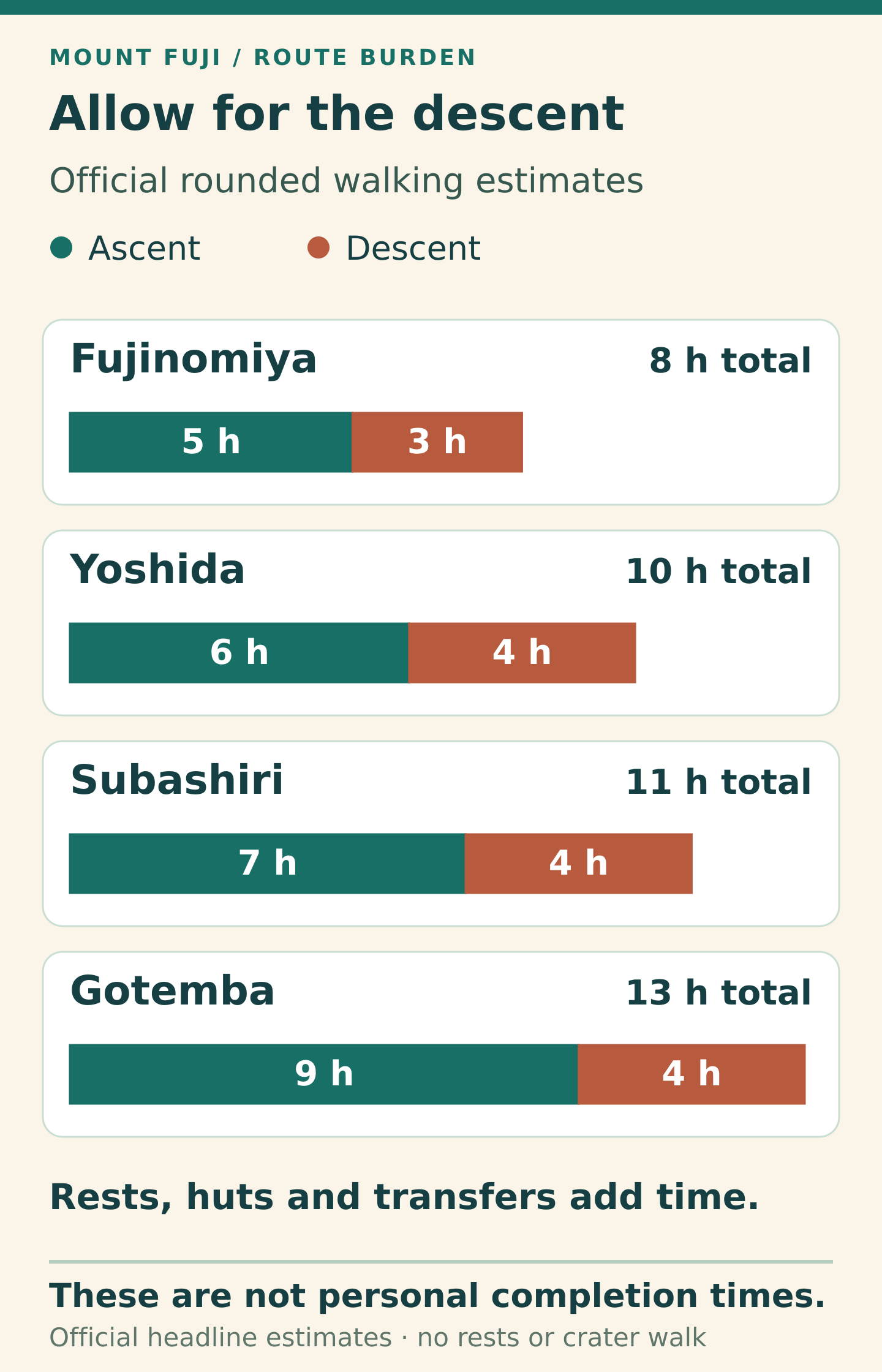
Choose the route before fixing the bus and hut. The official headline walking estimates make the first decision clear: the descent is a substantial part of the climb. These rounded estimates exclude rests; the detailed stage timings on the same official page differ. Treat them as a comparison, then allow for your own pace, queues and conditions. [5]
| Route | Start elevation | Ascent | Descent |
|---|---|---|---|
| Yoshida | 2,305 m | About 6 hours | About 4 hours |
| Fujinomiya | 2,400 m | About 5 hours | About 3 hours |
| Subashiri | 2,000 m | About 7 hours | About 4 hours |
| Gotemba | 1,440 m | About 9 hours | About 4 hours |
Source: the official route comparison. The chart below adds ascent and descent; it does not predict an individual finish time. [5]
Which route fits?
Yoshida is the strongest starting point for a prepared first-time Fuji climber who wants a broad choice of huts. It has more huts than the other routes, although this is a reason to compare locations and availability, not a guarantee that a bed will be free. Its upper trail joins Subashiri, so choosing the latter does not avoid every shared section. [6]
Fujinomiya’s shared ascent and descent path is steep and rocky: the short distance still demands controlled downhill walking and consideration for other climbers. Subashiri offers a forested lower approach before joining the upper Yoshida route; its separate descent and the eventual route split require attention. [8] [9]
Gotemba is the poor fit for anyone choosing by minimum effort. Its long walking commitment needs an honest assessment of endurance, and the official facility table lists no first-aid centre on that route. A quieter-looking line on a map is not a support plan. [10]
Use this order: rule out routes whose hut or transport you cannot secure; compare the descent with the terrain you have trained on; then choose the scenery. If a long loaded practice walk already leaves your knees or feet struggling, changing to the nominally shortest route does not solve that problem.
On a narrow screen, swipe the diagram sideways to read the details.
Understand the official entry rules
The following rules describe 2026 and explain what to recheck when the next season is announced. Paying an entry charge and reserving a hut are separate tasks; neither is a promise that the route will remain open. [3] [4] [11]
| Requirement | Yoshida — Yamanashi | Subashiri, Gotemba and Fujinomiya — Shizuoka |
|---|---|---|
| Entry charge | ¥4,000 per person, per climb | ¥4,000 per person, per climb |
| Restricted entry hours | 14:00–03:00; hut guests exempt | 14:00–03:00; an overnight hut reservation required for entry during these hours |
| Other distinction | 4,000-person daily cap; hut guests exempt | Mandatory learning about rules and manners; registration and permit process |
Yamanashi’s notice also required suitable warm clothing, separate waterproof jacket and trousers, and appropriate climbing footwear. On-the-day entry processing was available, although advance arrangements remove one uncertainty. Follow the prefecture’s appointed instructors; its guidance says climbers lacking experience or sufficient mountain knowledge should be accompanied by a guide or professional. [3]
Shizuoka’s 2026 process used the FUJI NAVI app for registration, learning, payment and a QR permit, with an on-site route also available. Do not assume a Yoshida reservation covers a Shizuoka trail, or apply Yoshida’s daily cap to all four routes. [4]
For Yoshida, book entry for the day you pass the fifth-station gate, even if the summit attempt is the following morning. Hut guests still pay the entry charge. Keep the hut confirmation and relevant entry proof available offline. The official advice asks hut guests to enter before 14:00 for safety despite their exemption; avoid designing the day around the last moment you are legally allowed through. [11]
Reserve a hut and decide what a guide adds
An overnight plan is the sensible starting point for a first Fuji attempt: an afternoon ascent to a reserved hut, rest, then a further ascent only if conditions and health permit, followed by the descent. Do not substitute a continuous overnight “bullet climb” for a hut booking. Official advice warns against that pattern because of altitude illness and hypothermia. [11]
Huts are basic, often with shared mixed rooms, simple meals and no bathing or washing facilities. Confirm dietary requirements, check-in time and what the rate includes. A higher hut shortens the remaining ascent but asks more of the first day and means sleeping higher. Choose a hut you can reach without rushing, using the official Yoshida hut directory to contact it directly. [6]
For a concrete example of that trade-off, Taishikan describes its location at about 3,100 m and estimates three to four hours both from the fifth station to the hut and from the hut to the summit. Those are walking estimates, not a promise of an easy second day. A single night at a high hut also does not establish full acclimatisation. [30] [17]
Three guided formats worth comparing
A guide can help with pace, route decisions and coordination, but cannot guarantee a summit, sunrise or safe weather. For any future departure, confirm that the official route is open, the selected itinerary suits your fitness, and the operator’s weather and illness procedures are acceptable. Check the precise option before paying.
Compare a private two-day Fuji climb on GetYourGuide if you want a guide and a choice of routes while retaining control of the hut. The listing explicitly leaves hut accommodation to a separate booking; it describes Yoshida, Subashiri, Fujinomiya and the Prince Route, so check the actual line rather than assuming every official route is offered. Transport varies by option. This suits someone willing to coordinate those pieces, not someone expecting one inclusive purchase. [12]
Compare the three-day guided climb on GetYourGuide if you can give the mountain more calendar space. Its itinerary includes a night at the base and an eighth-station hut night, with sunrise between the eighth and ninth stations before continuing towards the summit. It uses a local meeting point. Confirm meals, entry fees, equipment and insurance against the selected departure; the extra night is a pacing choice, not protection from altitude illness. [13] [17]
Compare H.I.S.’s two-day Tokyo departure on Viator if a Shinjuku coach, an English-speaking guide and an overnight hut make the logistics easier. The listing describes included rainwear and a helmet, with further rental upgrades. It requires strong fitness and currently states that the booking is non-refundable and cannot be changed. Check entry-fee coverage, gear sizes and the hut allocation before buying; this format is a poor match if flexible cancellation is essential. [14]
Work backwards from the return journey
The summit is an optional turning point; the descent remains. Before starting, write down the correct return trailhead, the actual bus service you intend to use, a personal latest summit-departure time and an earlier point for reassessing progress. The official health guidance specifically asks climbers to research their descent and final transport. [15]
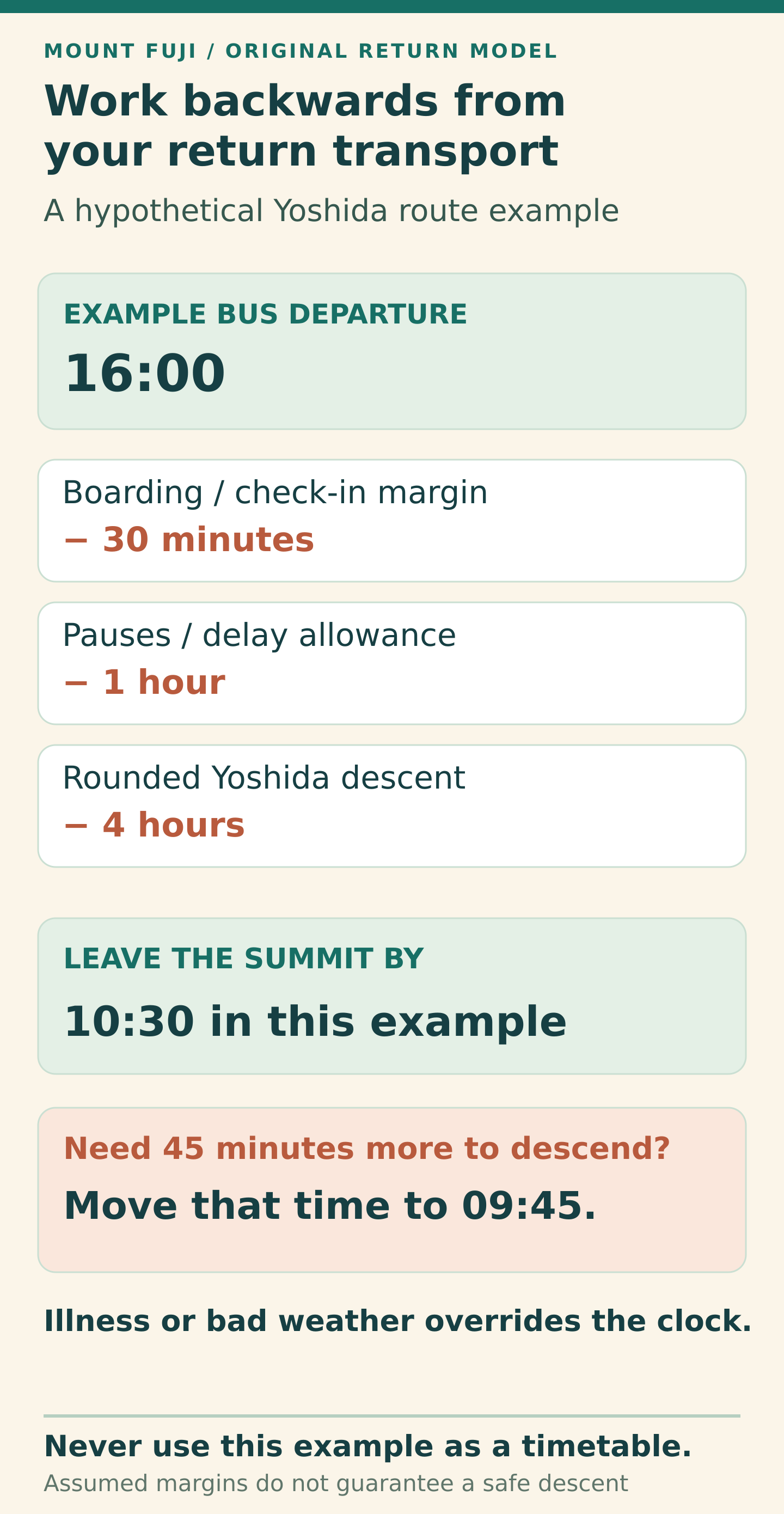
Worked planning example — not a timetable: suppose a Yoshida return bus leaves at 16:00. Subtract 30 minutes to reach the stop and board, one hour for pauses and delays, and the rounded four-hour descent estimate. The resulting latest summit departure is 10:30. If your descent needs another 45 minutes, it becomes 09:45. The bus time and the first two allowances are original assumptions; replace them with the real service and your own needs. [5]
This arithmetic tests whether a plan has enough transport margin. It does not certify that climbing until 10:30 is safe. Symptoms, slowing progress or worsening weather require an earlier decision, even if that means abandoning the summit.
Do not add a crater circuit automatically. The official Yoshida map allows about 90 minutes for the circuit and distinguishes the Yoshida summit area from Kengamine, Fuji’s highest point. That is further walking after reaching the rim. Drop it when visibility, energy or the return margin is poor; a route-top arrival does not oblige you to circle the crater. [7]
On descent, pause and regroup at the Yoshida–Subashiri fork near Shita-Edoya at the eighth station. Confirm the route name and colour: yellow for Yoshida, red for Subashiri. Following other climbers can deliver you to a different fifth station. Keep an offline map and check signs again after breaks, especially in mist. [27]
Reserve a recovery evening after the descent rather than a tight onward connection. A missed train is inconvenient; planning to borrow time from the descent is a worse decision.
On a narrow screen, swipe the diagram sideways to read the details.
Prepare your body, equipment and communications
Practise sustained uphill and downhill walking in the boots and loaded pack you will use. The official advice recommends a one- to two-hour rest at the fifth station before ascending. Treat that as a pause to adjust and assess how you feel, not as complete altitude acclimatisation. [15]
Fitness helps the work of climbing but does not protect against altitude illness. Rapid ascent remains relevant even to strong walkers. If you have heart or lung disease, another relevant condition, or previous altitude problems, discuss the itinerary with a clinician familiar with altitude before committing. A slower ascent profile may be more suitable than squeezing Fuji into fixed dates. [16] [17]
Pack for cold, rain and a long descent
The official equipment list calls for proper hiking boots, waterproof jacket and trousers, insulating clothing, gloves, a headtorch with spare power, a hands-free hiking pack, water and food, sun protection, a map, first-aid supplies, cash and toilet coins. A helmet is recommended for rockfall risk. Check soles, straps and lighting before departure; keep rainwear accessible and spare warm layers dry. [18]
Plan water and food around your pace and the huts that will actually be open. Confirm where you can buy supplies rather than assuming every named building is operating. The facility calendar also shows that first-aid services do not necessarily cover every date of a trail’s open season. [10]
For a headtorch, prioritise a usable walking beam, a secure fit, controls you understand and sufficient runtime plus spare power. As one specification-based example, the Petzl TIKKA CORE accepts its rechargeable CORE battery or three AAA/LR03 batteries. Its brightest setting has a shorter runtime than its standard setting, so headline brightness is not the whole buying decision. Test the exact model you obtain before the trip. [19]
Keep the route map, hut confirmation, contact details and entry proof offline, with a charged phone and power bank. Compare Japan data options through Airalo if your phone supports eSIM and is network-unlocked. The Japan plans checked were data-only: arrange how you will make voice calls separately. A data plan does not guarantee mountain reception or replace an emergency plan. [20] [21]
Carry out your rubbish, remain on marked trails and leave rocks and plants in place. Tent pitching and campfires are prohibited. A hut reservation is the accommodation solution for this climb. [18]
Make the weather decision more than once
Fuji’s summit weather can differ sharply from the fifth station and the towns below. Summer temperatures near dawn can approach 0°C, and wind and wet clothing increase the danger of cooling. A clear Tokyo forecast is not a summit forecast. Check the official mountain-weather links, relevant Japan Meteorological Agency warnings and the actual trail status before setting out; recheck with hut staff as the climb develops. [22]
Leave the climb for another date when the forecast or official advice is poor. A favourable forecast still cannot assure safe conditions. If wind affects balance, visibility prevents reliable route-finding, or a thunderstorm develops, stop treating the original summit plan as a target to preserve. Seek a safe staffed hut or other appropriate shelter and follow local instructions; avoid a discretionary crater walk in adverse conditions. [24] [26]
Fuji is an active volcano. Check JMA’s current Fuji volcanic information and comply with any access restrictions or evacuation instructions. A low alert level is not an all-purpose assurance of safety. [23]
Recognise illness and know how to get help
Altitude symptoms: stop ascending
Headache with nausea, dizziness, unusual tiredness or appetite loss after ascending may be altitude illness. Tell your companion or guide and stop gaining height. Do not continue upwards while symptoms remain. If symptoms worsen while resting at the same altitude, descend and seek help; do not try to rescue the summit attempt by pushing through. [16]
Confusion, marked unsteadiness, unusual drowsiness or breathlessness at rest can signal a severe altitude emergency. Arrange urgent rescue and assisted descent where it can be done safely, minimising exertion and keeping the person accompanied. If they cannot move safely, seek shelter and follow rescue instructions. Small disposable oxygen cans are not a substitute for descent or proper emergency treatment. [17]
Cold illness: shelter and warm the person
Shivering, slurred speech, slow breathing, exhaustion or confusion can indicate hypothermia. Get the person into shelter, remove wet clothing and wrap them in dry layers or blankets, including the head. Stay with them and call for emergency help. Give a warm non-alcoholic drink or sugary food only if they are fully awake. Do not rub their limbs or apply intense direct heat. [25]
In Japan, call 119 for fire and ambulance or 110 for police. The official Fuji emergency page also lists 090-5190-0167 for the Yoshida fifth-station administration centre. State the trail name, station or nearest hut, any numbered location sign, what happened, the number of people and the casualty’s condition. Hut staff can help summon assistance. Save these details before the climb. [26]
If you lose the route, stop and compare the signs, map and your position; do not improvise a shortcut down loose slopes. If you cannot locate the correct trail, wait in a safe place and request help. Rescue vehicles are not a planned alternative for tired legs, and emergency transport can involve costs. [15] [26]
Before booking, check insurance against the actual activity: trekking to 3,776 m, medical treatment and mountain rescue or evacuation, plus any guide requirement or exclusions. Get the insurer’s answer in writing. A tour’s mention of insurance is not enough to establish the cover you need. [35]
Match transport, a base and the full cost
For Yoshida, distinguish Kawaguchiko or Fujisan Station from the Fuji Subaru Line fifth station where the usual climb starts. The local bus is a separate journey. Compare Tokyo–Kawaguchiko buses on 12Go for the foothill transfer, then check the official fifth-station bus timetable for the relevant operating season. The transport booking does not include mountain entry. [28] [34]
For the Shizuoka side, Gotemba is a transport base for Subashiri and Gotemba approaches; Fujinomiya uses its own fifth-station approach. Match the bus stop and hut to the same route. Seasonal road restrictions also differ, so renting a car does not automatically remove the final transfer. [8] [9] [10]
For Yoshida, compare Fujikawaguchiko accommodation on Booking.com and Fujikawaguchiko accommodation on Agoda, using the map to check the walk to your actual departure point. For a Gotemba-side plan, use Booking.com’s Gotemba accommodation search. These are town-stay searches; reserve a mountain hut separately. Before paying, ask about your arrival time and whether luggage can stay during the climb. [31] [32] [33]
A dated cost example, with the assumptions visible
The following one-person Yoshida example uses published 2026 charges. It is a reference for judging the scale of the commitment, not a 2027 quote or a currently bookable climb.
| Item | Amount | Basis |
|---|---|---|
| Entry | ¥4,000 | 2026 Yoshida charge |
| Taishikan shared room, two meals | ¥14,500 | Ordinary Sunday–Thursday 2026 rate; specified holiday dates cost more |
| Fifth-station return bus | ¥3,400 | Adult fare from 1 July 2026; return ticket valid for two days |
| Published-charge subtotal | ¥21,900 | Sum of the three lines above |
| Lunch, extra water, snacks and toilet coins | ¥3,000 | Original planning allowance; adjust for your needs |
| Illustrative total | ¥24,900 | Excludes Tokyo travel, town hotels, gear, guide and insurance |
Published charges: Yoshida notice, Taishikan’s 2026 rate table and Fujikyu Bus. Taishikan lists higher rates on Fridays, Saturdays and specified dates, and a cancellation charge from booking. Check the current price calendar and cancellation terms before committing. [3] [28] [29]
Do not fund the climb by removing the warm layer, hut rest or return margin that makes your plan workable. If the total feels too high, change the trip. Use the Japan trip-cost guide to place this separate mountain expense within the wider holiday budget.
Your Mount Fuji climbing questions answered
Does the 14:00–03:00 entry restriction prevent me from descending?
No. The official Yoshida FAQ says the gate can be passed on descent regardless of time. The restriction governs entry; it is not a reason to stay high when you need to come down. Recheck the next season’s instructions before travelling. [11]
Do I have to reach the summit for sunrise?
No. Taishikan’s guidance says sunrise can be seen from the Yoshida route above the sixth station, when conditions allow. A lower viewpoint may remove the pressure to rush uphill in darkness. Cloud can obscure sunrise anywhere; choose your turning point for the climb you can manage. [30]
Can I rely on being fit or having climbed Fuji before?
Neither removes altitude risk. Fitness does not prevent altitude illness, and an earlier successful ascent does not guarantee the same response on another trip. Make decisions from your current symptoms and conditions, not a previous summit photograph. [17]
When should I reserve for 2027?
There is no confirmed 2027 booking date to give from the official information checked here. Watch the new prefectural notices and your chosen hut’s own announcement. Do not reuse the 2026 opening dates or assume a platform listing proves official access has been arranged. [3] [4] [29]
Choose the plan that fits your trip
Choose Fuji when you can give the mountain suitable conditions, preparation and room to change the plan. For a first attempt, a reserved overnight Yoshida itinerary is a useful starting point; change route only for a clear reason you can support with fitness, hut availability and transport. If the next season, your health or the weather does not fit, leaving the summit for another trip is a complete decision.
How this guide was researched
Based on current official climbing notices, route maps, hut and transport information, authoritative medical guidance and the booking pages described. Route recommendations and time or spending allowances are editorial planning judgements. This guide does not claim a personal climb or equipment test.
Sources and checks
Official, operator and relevant booking information checked on 17 October 2026 and 18 October 2026. Opening arrangements, fares and availability can change; recheck the linked source for your travel dates.
- Official Mount Fuji Climbing Website — current closure notice
- Official Mount Fuji Climbing Website — outside the climbing season
- Yamanashi — Yoshida Trail 2026 regulations
- Shizuoka — 2026 climbing regulations and revised opening dates
- Official Mount Fuji route comparison
- Official Yoshida mountain-hut directory
- Yoshida Trail official English map, 2026
- Subashiri Trail official English map, 2026
- Japan National Tourism Organization — Fujinomiya fifth station and route
- Official Mount Fuji facility operating periods, 2026
- Official Mount Fuji climbing FAQs
- GetYourGuide — private two-day guided summit climb
- GetYourGuide — three-day guided Mount Fuji hike
- Viator — H.I.S. two-day Mount Fuji climb from Tokyo
- Official Mount Fuji health and safety guidance
- CDC — travel to high altitudes
- CDC Yellow Book — high-altitude travel and altitude illness
- Official Mount Fuji preparation, equipment and protected-area rules
- Petzl — TIKKA CORE specifications
- Airalo — Japan eSIM plans
- Airalo — device compatibility
- Official Mount Fuji mountain-weather resources
- Japan Meteorological Agency — Fuji volcanic information
- Official Mount Fuji accident and risk information
- NHS — hypothermia
- Official Mount Fuji emergency guidance
- Official Mount Fuji navigation and descent-fork advice
- Fujikyu Bus — fifth-station timetable and fares
- Taishikan — 2026 reservations and accommodation charges
- Taishikan — English hut information
- Booking.com — Fujikawaguchiko accommodation
- Agoda — Fujikawaguchiko accommodation
- Booking.com — Gotemba accommodation
- 12Go — Tokyo to Kawaguchiko buses
- FCDO — Japan travel advice and travel insurance
Illustrations in this article were created for Taylor’s Trailblazing Travels. Third-party photographs, where used, are credited beside the image or in the source list.