Japan · Walking & Pilgrimage
Kumano Kodo Hiking: Choosing Your First Pilgrimage Route
Choose a stage you can enjoy, an overnight you can book and a finish you can reach without rushing.
Kumano Kodo hiking begins with choosing a realistic stage, not committing to an entire line on a map. These pilgrimage routes cross the Kii Peninsula towards Kumano’s sacred sites; the walk is part of a religious and cultural landscape, not simply a single long-distance track.[1]
For a first trip, the useful question is how much mountain walking you want between dependable places to sleep or catch transport. The choices below separate a short approach to Hongu, an overnight mountain introduction and longer routes that demand more experience.
Taylor’s Trailblazing Travels may earn a commission when you book or buy through an affiliate link in this guide, at no extra cost to you. This helps fund the research and upkeep of the site.
Start with the finish
A shrine arrival or confirmed inn is more useful than a distance target that leaves the final connection unresolved.
Short can still be steep
Takijiri–Takahara needs a mountain-walking assessment and an overnight or onward plan, despite its short distance.[3]
Keep the bus gap honest
Combining selected stages by bus makes a flexible introduction; it does not turn them into a continuous trek.
Protect your usable day
Walking estimates need room for meals, rests, access and delays before comparing them with a dinner or bus deadline.
Choose your first Kumano Kodo hiking route
Start with four questions: how long can you comfortably walk on hills; how many regional nights can you spare; which beds can you actually confirm; and where can you finish if the day goes slowly? A route passes only when all four answers work. A short distance alone is a poor selection rule.
| One-way stage | Walking commitment | Choose it when… |
|---|---|---|
| Hosshinmon-oji → Kumano Hongu Taisha | 7.5 km; 2–3 hours; about 190 m ascent and 460 m descent.[2] | You want a village-and-forest approach ending at the grand shrine. |
| Takijiri-oji → Takahara | 4 km; 2–3 hours; about 430 m ascent and 200 m descent.[3] | You want the steep mountain opening and have a confirmed overnight or exit plan. |
| Takahara → Chikatsuyu-oji | About 9.3 km; 3½–4½ hours, calculated from the two official subsections.[4][5] | You can manage a longer hill day after sleeping in Takahara. |
| Chikatsuyu-oji → Kumano Hongu Taisha | 24.5 km; 9–12 hours; about 1,100 m ascent.[6] | You already have substantial walking experience and a realistic long-day plan. |
On a small screen, swipe inside the table to see every column.
For the least complicated introduction, start with the Hongu approach. Its overall descent does not remove the climbing, steps or uneven ground. If prolonged descents are a problem, check the detailed profile and discuss a smaller section or shrine visit with a local guide.
The first two mountain stages suit a different goal: experiencing an overnight journey between settlements. They are not an easier substitute simply because the first day’s distance is shorter. The Takahara–Chikatsuyu calculation is 8 km plus 1.3 km, and 3–4 hours plus roughly 30 minutes; walks to the actual accommodation are additional.[4][5]
A three-day introduction with the long middle section optional
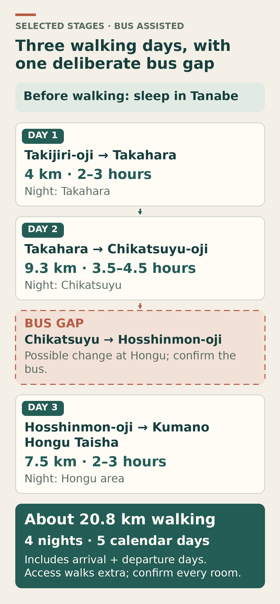
This suggested plan gives you two mountain stages and the arrival at Hongu without making the longest connecting day compulsory. It uses a bus between Chikatsuyu and Hosshinmon-oji, so it is a selection of walks rather than a continuous Takijiri–Hongu trek.
- Arrive in the region the day before walking and sleep in central Tanabe. This protects the first mountain day from a late intercity arrival.
- On walking day one, take a bus to Takijiri, walk to Takahara and stay there. There is no bus stop in Takahara itself; the official route notes put Kurisugawa, the nearest stop, about 30 minutes away on foot.[3]
- On walking day two, continue to Chikatsuyu via Gyuba-doji-guchi and sleep in Chikatsuyu. Check the inn’s precise position: the village and the nearby Nonaka accommodation area are separate stops along the route.[9]
- On walking day three, use a suitable bus to Hosshinmon-oji, potentially changing at Hongu Taisha-mae, then walk into Hongu. Reserve the final night in Hongu village or a nearby onsen settlement.[7]
Allow five calendar days if you add a separate arrival day and departure day, with four nights: Tanabe, Takahara, Chikatsuyu and the Hongu area. The selected trail sections add to about 20.8 km; this excludes station, bus-stop and accommodation walks. Those totals are an editorial planning model, not a bookable package.
If you only have two regional nights, base them around the Hongu approach instead of trying to compress this whole sequence. If you want uninterrupted walking, the Chikatsuyu–Hongu day needs its own assessment. Moving the start to Doyukawa-bashi still leaves roughly 17 km and 6–9 hours; it is a substantial day, not a casual shortcut.[7]
Turn walking time into a usable day budget
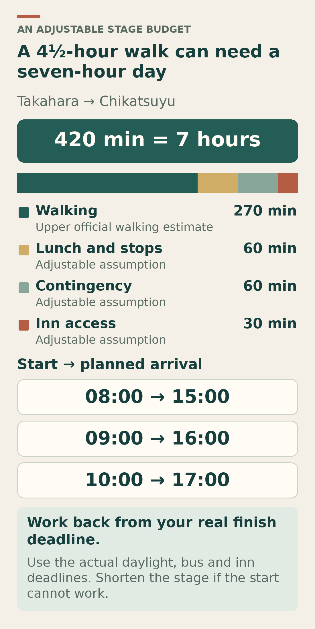
For the Takahara–Chikatsuyu day, take the upper end of the published subsection times: four hours to Gyuba-doji-guchi plus half an hour onward. That gives 270 minutes of walking before lunch, photography or the final approach to your room.[4][5]
| Component | Minutes | What the allowance does |
|---|---|---|
| Walking | 270 | Uses the upper end of 3–4 hours plus 30 minutes. |
| Lunch and other stops | 60 | Keeps eating and looking around out of the walking estimate. |
| Contingency | 60 | Leaves spare time for slower progress or small delays. |
| Accommodation access | 30 | A placeholder to replace with your inn’s actual location. |
| Total planned elapsed time | 420 | Seven hours from setting out to reaching the accommodation. |
On a small screen, swipe inside the table to see every column.
Under these assumptions, an 08:00 start means a planned 15:00 arrival; 09:00 means 16:00; 10:00 means 17:00. A slower walker must increase the walking input. An earlier dinner or pickup deadline may require an earlier start or a shorter stage.
Work backwards from the earliest constraint: the inn’s agreed arrival time, a necessary bus departure minus time to find the stop and board, or the time by which you need to leave the trail before dark. Subtract the whole elapsed budget. If the resulting start cannot be achieved, alter the route or overnight stop before booking. The spare hour cannot make a closure, severe weather or unsuitable terrain acceptable.
Book the beds and luggage plan together
Takahara, Chikatsuyu/Nonaka and Koguchi can fill up in busy periods. The tourism bureau suggests changing the walk and using buses from places with more accommodation capacity, including Tanabe, Katsuura and Kawayu. A room elsewhere in the municipality is not automatically a usable substitute for a trail-side bed.[18]
- Identify the smallest settlement on your chosen route and check that night’s options first. For the three-day introduction, that means resolving Takahara before committing to the surrounding nights.
- Request the whole sequence, including meals, arrival deadlines and any agreed transfers. Explain dietary requirements before paying, and establish where each day’s lunch will come from.
- Confirm how your main bag will travel. Check which booking channel and properties the luggage provider accepts.
- Finalise the remaining nights and transport once the essential stage connections work. Save confirmation details and cancellation terms offline.
KUMANO TRAVEL’s local reservation system uses a request process. Receiving the request acknowledgement does not confirm a bed; after processing, payment is required to finalise it. Its published process gives 48 hours to pay after the processed-request email.[19] New requests currently open only at 07:00–09:30 and 19:00–22:00 Japan time; check those hours when submitting.[20]
Its daily luggage shuttle currently requires booking at least 20 days ahead and accommodation booked through KUMANO TRAVEL, with particular station and Takijiri collection options. Booking a bed elsewhere does not establish shuttle eligibility. Ordinary onward luggage shipping is a different service: confirm the receiving property and delivery date, then carry what you need until it arrives.[21]
For a coastal arrival night, compare Tanabe stays on Agoda and filter around Kii-Tanabe Station. The destination search also covers outlying areas.[23] For the shorter Hongu plan, compare Hongu-area stays on Booking.com; results include separate onsen settlements, so check the map and the exact bus stop.[24] Compare total meals, transfers and luggage arrangements as well as the room price; no dates or room availability are assumed here.
Choose buses and exit points before the walk
For the western approach, Kii-Tanabe is the main bus connection for Takijiri and the Hongu area. Save the tourism bureau’s current bus timetables: numbers 1 and 2 cover the Tanabe–Hongu corridor, 6 focuses on Hosshinmon-oji, and 11 connects Hongu with the onsen villages. Check the complete column for your service; not every bus reaches every stop.[10]
Peak spring and autumn buses may be full, and a rural taxi is not a dependable last-minute rescue plan. Record a second workable departure and what you will do if neither fits. Carry some yen cash; arrangements vary. In particular, the official autumn 2026 extra-bus notice excludes Suica and ICOCA, but lists cash and supported contactless credit cards as payment methods. Check your particular operator rather than assuming that an urban transport card works throughout the region.[11][12]
At this review, additional autumn buses are advertised for 19 September–10 December 2026, including a Kii-Tanabe–Hosshinmon express and an extra onsen-area departure. They provide date-specific alternatives, with first-come boarding and possible capacity limits; they are not year-round services or reserved seats.[12]
Where the plan can change
- Before the Takijiri climb, reassess the conditions while you are still beside the road and bus route.
- At Takahara, use the exit agreed with your host; do not begin the next forest stage assuming buses run through the village.
- At Gyuba-doji-guchi, a road-side bus stop gives another decision point before the final section into Chikatsuyu.[4]
- At Hosshinmon-oji, there is no accommodation. Starting here and finishing towards Hongu avoids designing the day around reaching an unbooked bed at the trailhead.[2]
A road drawn beside a trail is not necessarily a public bus route or a place where a vehicle can collect you. Mark the actual stop, access path and last useful service on the official map before treating it as an exit.
When another Kumano route is the better choice
The Nakahechi starting options above cover different portions of one route family. Reaching Hongu does not mean you have also reached Nachi or Hayatama. Choose any extension as a separate walking decision.
Hongu to Nachi: a further mountain commitment
Kogumotori-goe connects Ukegawa in the Hongu area with Koguchi; it includes forested climbing and descent, with slippery stone steps possible.[17] The following Ogumotori-goe to Nachi is among Nakahechi’s toughest stages: the current route page gives about 14 km and 7–9 hours, with an initial southbound climb of roughly 800 m in 5 km. Reversing direction turns that climb into a major descent. Resolve the Koguchi bed and transport before adding it.[16]
Kohechi: choose for experience, not its shorter-looking line
The Koyasan–Hongu mountain route has high passes, more isolated northern sections and limited facilities. The bureau recommends it for experienced walkers and warns of snow-bound passes in winter. Its current booking guidance requires the full accommodation sequence to be confirmed, with only two inns in Miura-guchi. It is a poor fallback when an easier Nakahechi itinerary cannot be booked.[14]
Iseji: useful when the eastern approach suits your trip
The Iseji links Ise with Kumano along the eastern peninsula. Selected passes can work as day walks because many trailheads are near railway stations. That makes it worth investigating if you want independent day stages from a coastal base, but choose a particular pass and check its ascent and transport; the full route is about 170 km.[15]
The coastal Ohechi requires its own planning too. Its current southern closure is listed in the notices below; choosing a coastal name does not establish that a continuous walk is possible.
Match the season and check the current trail notices
Spring and autumn are popular. Nakahechi is generally walked year-round, but winter can bring freezing conditions and high-level snow; summer is often hot, humid and wet. Prepare for rain, changing mountain conditions and shorter winter daylight.[22]
| Section | Published position | Planning consequence |
|---|---|---|
| Nakahechi: Nakado-jaya remains–Jagata Jizo | The route returned to the original trail via Iwagami-oji on 1 October 2025.[13] | Use current maps; an older detour description may mislead you. |
| Kohechi: north side of Obako-toge | A landslide detour over the peak remains listed.[13] | Check the detour’s exact line and conditions before committing. |
| Ohechi: Wabuka Station–Tako Station | Closure for construction from 8 June 2026 to an estimated 30 April 2027; the notice directs walkers to bypass by train or bus.[13] | Do not plan this as a continuous walking section. |
On a small screen, swipe inside the table to see every column.
Open the official trail-conditions page while planning and again before setting out. Ask your accommodation about that day’s local conditions. If weather, closures or illness make the chosen stage unsuitable, use your accommodation and transport alternatives instead of relying on the original timing model.
Choose independent walking or useful guiding
Independent walking gives you control over pace and stops, provided the navigation, stage length and booking work are within your experience. A local guide adds interpretation of the sacred sites and help with the chosen route. The tourism bureau lists local guiding options; distinguish a walking guide from a service that also arranges the whole accommodation sequence.[30]
For the short Hongu approach, check DeepExperience’s Hosshinmon–Hongu guided walk on Viator. The listing describes a private English-language walk of about 3½ hours. Its stated meeting point is Kumano Hongu Heritage Center, although the walking route begins at Hosshinmon-oji: confirm the transfer arrangement, extra costs and actual meeting time before booking. It is listed as not wheelchair accessible.[25]
If an overnight in Kumano cannot fit your trip, compare the Osaka-based Kumano highlights outing on GetYourGuide. Its current listing describes a 12-hour excursion with vehicle transport, a shorter forest walk from Fushiogami-oji and a Hongu visit. The benefit is arranged road transport; the trade-off is a long travel day and much less trail time. Check the walking distance, pickup area, footwear advice and weather policy for your date.[26]
For either option, choose by the actual stage and arrangements. A tour’s broad activity title does not establish that it covers the overnight journey, all three grand shrines or a particular pilgrim credential requirement.
Prepare for the stage you actually chose
Use worn-in footwear with grip, rainwear and layers. Carry food, sufficient water, a light source, a paper map and a charged phone. Save bus tables and bookings offline, leave your plan with someone, and keep your pack manageable.[22]
Mobile data can help with messages and updated transport information where a signal is available. You can browse Airalo and select a Japan eSIM. Check the exact plan’s activation terms and your device’s compatibility before buying; install while you have a stable internet connection.[27][28] Data service is not a promise of continuous trail coverage, and an offline map remains useful.
Allow time to stop at the oji shrines and at Hongu, rather than treating every pause as lost progress. The official Hongu map distinguishes the shrine approach from Oyunohara, the former shrine site, and from the separate Dainichi-goe and Akagi-goe trails. A nearby-looking onsen or optional loop can therefore add real walking to the day.[8]
Carry your rubbish out.[22] Be considerate at shrines and in the villages, and leave time to notice the setting: a smaller walk can meet the purpose of a first pilgrimage better than a schedule you spend the day trying to recover.
Frequently asked questions
Does a short walk qualify for Dual Pilgrim status?
A short walk alone does not confer Dual Pilgrim status. The programme requires a qualifying Camino de Santiago journey and a qualifying Kumano itinerary, plus registration. One Kumano option combines the Hosshinmon–Hongu walk with visits to Hayatama and Nachi; consult the current stamp list before planning. You can enjoy a pilgrimage walk without pursuing the credential.[29]
Can I walk the Nakahechi in reverse?
Assess the reversed stage rather than copying the forward timetable. A large descent becomes a climb, the accommodation changes ends, and your useful bus may run at a different time. A local host or guide can help check the actual start, finish and transfers. Direction is a planning choice, not a guarantee of an easier day.
Does a Japan Rail Pass cover the local trail buses?
Do not assume it does. The tourism bureau specifically notes that JR buses do not operate its listed local route system. Check the fare or a suitable regional bus product for your chosen operator and journey; the intercity rail journey and rural buses are separate parts of the plan.[10]
The next planning step
Choose the Hosshinmon–Hongu approach if this is your first test of walking in Kumano. Choose the Takahara overnight introduction when the mountain effort appeals and the beds work. Extend only after the longest day, the smallest overnight stop and the least flexible bus connection all fit your abilities and dates. A feasible route leaves you time to notice why you came.
Sources and further reading
Visitor information and booking conditions checked for this editorial review on 18 October 2026. Recheck the linked operators for your travel date; planning allowances are identified separately in the guide.
- Tanabe City Kumano Tourism Bureau: Kumano Kodo pilgrimage network
- Tanabe City Kumano Tourism Bureau: Hosshinmon-oji to Kumano Hongu Taisha
- Tanabe City Kumano Tourism Bureau: Takijiri-oji to Takahara
- Tanabe City Kumano Tourism Bureau: Takahara to Gyuba-doji-guchi
- Tanabe City Kumano Tourism Bureau: Gyuba-doji-guchi to Chikatsuyu-oji
- Tanabe City Kumano Tourism Bureau: Chikatsuyu-oji to Kumano Hongu Taisha
- Tanabe City Kumano Tourism Bureau: options for shortening the Chikatsuyu–Hongu walk
- Official Nakahechi route map: Hongu area walks
- Official Nakahechi route map: Takahara to Tsugizakura-oji
- Tanabe City Kumano Tourism Bureau: local bus routes and current timetables
- Tanabe City Kumano Tourism Bureau: riding buses during peak season
- Tanabe City Kumano Tourism Bureau: additional public transport, autumn 2026
- Tanabe City Kumano Tourism Bureau: route and service updates
- Tanabe City Kumano Tourism Bureau: Kohechi route
- Tanabe City Kumano Tourism Bureau: Iseji route
- Tanabe City Kumano Tourism Bureau: Ogumotori-goe
- Tanabe City Kumano Tourism Bureau: Kogumotori-goe
- Tanabe City Kumano Tourism Bureau: alternatives when small communities are fully booked
- KUMANO TRAVEL: how the request and confirmation process works
- Tanabe City Kumano Tourism Bureau: current reservation-request hours
- Tanabe City Kumano Tourism Bureau: luggage shuttle and storage conditions
- Tanabe City Kumano Tourism Bureau: trail preparation, weather and closures
- Agoda: Tanabe accommodation search
- Booking.com: Hongu accommodation search
- Viator / DeepExperience: Walk the Kumano Kodo to Kumano Hongu Taisha
- GetYourGuide: Kumano Kodo Highlights and Trail Walk Day Tour from Osaka
- Airalo: Japan eSIM plans and installation information
- Airalo: compatible devices
- Tanabe City Kumano Tourism Bureau: Dual Pilgrim requirements
- Tanabe City Kumano Tourism Bureau: local Kumano Kodo guides
Illustrations in this article were created for Taylor’s Trailblazing Travels. Third-party photographs, where used, are credited beside the image or in the source list.