
10 Best Waterfalls in Thailand for 2026: Routes, Swimming and Safety
A route-first comparison of scenery, swimming, walking effort, seasonal flow and the practical difference between a day trip and an expedition.
Thailand’s waterfalls can look wonderfully simple in a photograph: green forest, pale rock and a pool that seems made for swimming. The practical reality is more interesting. Flow can weaken after a dry spell, a clear pool can become unsafe after rain upstream, and a famous viewpoint can sit at the end of a route that takes several days rather than several hours.
This guide compares the best waterfalls in Thailand by route fit, walking effort, swimming potential, seasonal reliability and the time the whole outing genuinely needs. It also corrects a common Koh Chang naming mix-up by using Khlong Plu Waterfall near Khlong Prao, and it adds current 2026 access context for Thi Lo Su.
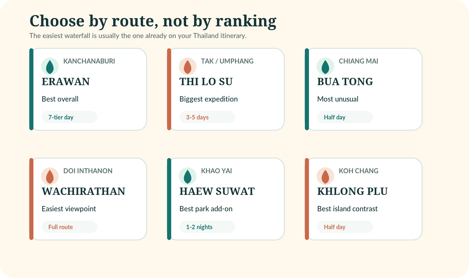
The central rule is simple: choose a waterfall that fits the trip you are already taking. Erawan belongs with Kanchanaburi, Bua Tong and Wachirathan belong with Chiang Mai, Haew Suwat belongs with Khao Yai, and Khlong Plu belongs with a Koh Chang stay. Thi Lo Su should be the purpose of a journey, not a hurried detour.
Erawan
Flexible levels and a full nature day from Kanchanaburi.
Thi Lo Su
A dedicated multi-day expedition, not a casual stop.
Bua Tong
An unusual active half-day on pale limestone terraces.
Swimming can close
Water level, debris and local rules decide what is safe.
Start with the map, not the photograph
A waterfall should improve an existing route rather than create a costly cross-country detour. From Bangkok, Erawan normally works better with at least two nights in Kanchanaburi, while Haew Suwat is more sensible as part of a one- or two-night Khao Yai extension. From Chiang Mai, Bua Tong can fill half a day and Wachirathan belongs inside a full Doi Inthanon loop. Travellers already on Koh Chang can reach Khlong Plu without returning to the mainland.
Decide whether the aim is scenery, swimming or a trail
These are not interchangeable. Wachirathan is an accessible, spray-filled viewpoint rather than a casual swimming stop. Thi Lo Su is about scale, forest and the expedition to Umphang. Erawan offers a sequence of levels, yet the upper trail demands more time and energy than the lower pools suggest. Phlio and Wang Kan Lueang often suit travellers who value gentler access and water-focused scenery, subject to current rules.
Research-led planning rule
Plan the outing as a nature day, not as a swimming guarantee. That removes the pressure to enter water when the current looks wrong, the pool is closed or recent rain has changed visibility.
Ask six questions before committing
| Question | Why it changes the plan |
|---|---|
| Is the attraction and final trail open? | Road access, walking routes and individual pools can close separately. |
| Is swimming currently permitted? | Permission changes with water level, current, debris and staffing. |
| What happened upstream? | Heavy rain outside the car park area can create a rapid rise or muddy flow. |
| How long is the return walk? | A short approach to the first viewpoint may hide a much longer full route. |
| What is the last sensible turnaround time? | Forest light fades earlier than city light and rain can slow the return. |
| Is the day still worthwhile without swimming? | A flexible plan prevents poor decisions made only to justify the journey. |
The table uses planning ranges rather than promises. “Swimming” means a site may have designated pools; it does not mean entry is permitted every day. The fee examples come from the DNP’s published schedule dated 2 June 2023, whose catalog record was updated in January 2026. Park notices and local collection arrangements can supersede a general schedule.
| Waterfall | Region/base | Standout reason | Best for | Effort | Realistic time | Fee pattern |
|---|---|---|---|---|---|---|
| Erawan | Kanchanaburi | Seven-tier forest day | Pools and progressive walking | Moderate; harder higher up | Full day | National-park fee; recheck |
| Thi Lo Su | Tak / Umphang | Remote scale and expedition | Scenery and adventure | Logistically demanding | 3-5 days | Sanctuary access arrangement |
| Wachirathan | Doi Inthanon | Powerful roadside viewpoint | Scenery on a mountain loop | Short approach; wet surfaces | 20-45 min stop | Doi Inthanon park fee |
| Bua Tong | Chiang Mai | Grippy limestone terraces | Active half-day | Moderate; hands useful | Half day | Local rules/fee can change |
| Haew Suwat | Khao Yai | Forest waterfall in major park | Park road trip | Short to moderate | Part of full park day | Khao Yai fee varies by area |
| Wang Kan Lueang | Lopburi | Spring-fed turquoise terraces | Relaxed water day | Low to moderate | Half day | Carry cash; local rules |
| Phlio | Chanthaburi | Clear pools and fish | Families and eastern route | Low to moderate | Half day | Published foreign adult fee: 200 baht |
| Ton Nga Chang | Songkhla | Seven southern forest levels | Hat Yai nature day | Higher levels harder | Half to full day | Local entry/parking may apply |
| Tad Ton | Chaiyaphum | Broad rainy-season cascade | Isan road trip and picnic | Low to moderate | Half day | National-park fee; recheck |
| Khlong Plu | Koh Chang | Island rainforest contrast | Short forest walk and pool | Low to moderate | 2-4 hours | Published foreign adult fee: 200 baht |
Fee note
The official schedule lists 200 baht for a foreign adult at Namtok Phlio and Mu Ko Chang. Khao Yai entries in the same schedule range from 200 to 400 baht depending on the area. Treat every figure as a dated budgeting example, bring some cash and verify the exact gate or attraction before travelling.
Erawan earns its place because it works at several speeds. Lower levels give active families and less confident walkers a rewarding nature outing, while travellers with time and suitable footwear can continue farther up the seven-tier route. The experience is therefore more flexible than a single-drop waterfall where the only decision is whether to enter one pool.
Route and time
Use Kanchanaburi as the logical base. A realistic planning range is about 1.5-2 hours each way from Kanchanaburi town, with a full day reserved for the experience. These are road-trip estimates rather than timetables; traffic, weather, stops and road works can move them substantially.
What changes on the day
Start early from Kanchanaburi rather than attempting a rushed return from central Bangkok. Carry water, keep food sealed where park rules require it, and decide a turnaround time before the upper trail. The path becomes more tiring and slippery as the day warms and crowds build.
Safety and practical judgement
The swimming image is appealing, but it should not define success. Park staff can close pools, restrict access or shorten the practical route after heavy rain. Even on an open day, only enter designated water and keep enough energy for the walk back.
When a booked option helps
A guided option can solve the long road transfer when you do not want to drive.
Thi Lo Su is the least interchangeable choice on this list. Its value lies in scale, forest and remoteness, but the journey to Umphang is part of the experience. Anyone with only a spare afternoon should choose a different waterfall rather than compressing the route.
Route and time
Use Tak province via Umphang as the logical base. A realistic planning range is roughly 4-6 hours by road between Mae Sot and Umphang before local access arrangements, with three to five days including access reserved for the experience. These are road-trip estimates rather than timetables; traffic, weather, stops and road works can move them substantially.
What changes on the day
A DNP notice dated 15 August 2026 announced reopening from 1 September 2026 after the annual wet-season closure and access work. That is useful current context, not a guarantee for a later date. Weather, road damage, sanctuary protection or operational decisions can still change access at short notice.
Safety and practical judgement
Use an established local arrangement, confirm the permitted transport and walking process, and respect the wildlife-sanctuary rules. The 2026 notice specifically reinforced low-impact behaviour, including taking waste out and avoiding disturbance. Do not treat a generic driving-map estimate as a complete access plan.
Wachirathan is a high-impact sight with a comparatively low approach commitment. Spray fills the viewpoint when flow is strong, and the cooler mountain air can feel surprisingly different from Chiang Mai city. It is a particularly good choice for travellers who want waterfall scenery without a long forest trail.
Route and time
Use Doi Inthanon, Chiang Mai province as the logical base. A realistic planning range is about 1.5-2 hours from central Chiang Mai depending on traffic and mountain stops, with part of a full Doi Inthanon day reserved for the experience. These are road-trip estimates rather than timetables; traffic, weather, stops and road works can move them substantially.
What changes on the day
The waterfall makes most sense inside a Doi Inthanon route that also includes selected viewpoints, pagodas or a permitted nature trail. Driving to the mountain for this one stop wastes the wider value of the day. Avoid cramming every attraction into the schedule; mountain weather and slow traffic reward a little slack.
Safety and practical judgement
This is not the place to build a swimming plan. Wear shoes with grip, protect a camera or phone from spray and carry a light layer. Smooth viewing areas and steps can be wet even when there has been no recent rain in the city.
When a booked option helps
A tour or private driver can simplify the mountain-road route and multiple stops.
Bua Tong is famous for mineral-rich limestone that feels grippier than ordinary dark waterfall rock. That makes moving beside and over the flowing water the attraction itself. It is an active experience rather than a distant viewpoint, and it suits groups who want something physically engaging without the logistics of a multi-day trail.
Route and time
Use north of Chiang Mai as the logical base. A realistic planning range is about 1-1.5 hours each way from central Chiang Mai, with half a day, or longer with a nearby stop reserved for the experience. These are road-trip estimates rather than timetables; traffic, weather, stops and road works can move them substantially.
What changes on the day
The “Sticky Waterfall” nickname can create false confidence. Algae, leaves, worn edges, crowded sections and ordinary wet steps still demand care. Use fixed ropes or handholds where provided, keep children close and move at the pace of the least confident person.
Safety and practical judgement
A driver or organised trip is often easier than relying on a last-minute return ride. Go earlier in the day for more space, bring clothes that dry quickly and keep valuables in a properly closed bag. TAT’s June 2026 feature describes the limestone layers and year-round green setting, although local conditions still govern access.
Haew Suwat works because Khao Yai offers a wider nature day: viewpoints, forest, wildlife awareness and several possible stops. The waterfall alone is not a strong reason to spend six or seven hours in a vehicle. With a nearby overnight stay, however, it becomes a natural part of a slower park route.
Route and time
Use Khao Yai National Park as the logical base. A realistic planning range is about 2.5-3.5 hours from central Bangkok before park circulation, with one full park day; one or two nearby nights are better reserved for the experience. These are road-trip estimates rather than timetables; traffic, weather, stops and road works can move them substantially.
What changes on the day
Swimming and trail access should never be assumed. Follow the barrier and ranger position you find on the day. Khao Yai also requires disciplined driving: never stop in a dangerous position to photograph wildlife and never leave a vehicle to approach an elephant.
Safety and practical judgement
The DNP fee schedule contains more than one Khao Yai entry, including different foreign-adult rates for different areas. That is precisely why a single price copied from an old blog is unreliable. Check the gate you will use, allow for vehicle charges and carry identification plus cash.
When a booked option helps
A guided route is useful for travellers who want transport and a coherent park day.
Wang Kan Lueang is spring-fed and visually gentler than the tall forest drops elsewhere in this guide. Water passes over low limestone terraces into turquoise pools, creating a relaxed day rather than a summit-style challenge. TAT’s 2026 feature highlights its year-round spring source and central location.
Route and time
Use Lopburi province as the logical base. A realistic planning range is about 2.5-3.5 hours from Bangkok depending on traffic, with half a day at the site within a wider road trip reserved for the experience. These are road-trip estimates rather than timetables; traffic, weather, stops and road works can move them substantially.
What changes on the day
The lower effort is the appeal. Families and mixed-ability groups can focus on shade, water and a picnic-style pace, though wet rock and changing local rules still matter. Weekends and public holidays can make a quiet-looking site feel much busier than weekday photographs suggest.
Safety and practical judgement
Treat the journey from Bangkok as a road-trip day rather than a quick city excursion. Confirm opening information locally, bring cash, keep soap and food waste away from the water, and leave if staff restrict a pool. A smaller waterfall can be the better choice when the aim is an easy shared day.
Phlio combines relatively easy access, clear forest water and visible fish. The DNP park page places the attraction about 14 kilometres from Chanthaburi, which makes it far more convincing as part of an eastern Thailand stay than as a hurried standalone dash from Bangkok.
Route and time
Use Chanthaburi province as the logical base. A realistic planning range is about 20-40 minutes from Chanthaburi town; roughly 3.5-4.5 hours from Bangkok, with half a day, preferably within a Chanthaburi or Trat route reserved for the experience. These are road-trip estimates rather than timetables; traffic, weather, stops and road works can move them substantially.
What changes on the day
Fish are wildlife, not props. Do not chase, touch or feed them unless staff explicitly authorise a controlled practice. Water clarity can change after rain and designated swimming areas may change, so treat the pool seen in an old photograph as context rather than permission.
Safety and practical judgement
The published DNP fee schedule lists 200 baht for a foreign adult and 100 baht for a foreign child at Namtok Phlio. Those are dated planning figures from the 2023 schedule, not a promise of today’s gate price. Bring secure shoes even though the approach is easier than the upper Erawan trail.
Ton Nga Chang gives a southern city itinerary a proper rainforest day. Its seven levels become progressively more demanding, while the name refers to the twin streams resembling elephant tusks. TAT included it as the southern choice in its June 2026 five-region waterfall feature.
Route and time
Use near Hat Yai, Songkhla province as the logical base. A realistic planning range is about 45-60 minutes from central Hat Yai in normal conditions, with half a day for lower areas; a full day for a stronger walk reserved for the experience. These are road-trip estimates rather than timetables; traffic, weather, stops and road works can move them substantially.
What changes on the day
Lower sections suit more visitors. Higher levels need better footwear, fitness, water and time, especially in humid conditions. Decide in advance that reaching every level is optional; heat and rain can turn a reasonable upward walk into a tiring descent.
Safety and practical judgement
Check recent rain and follow the staff’s safe boundary. The stronger flow that improves photographs also raises the risk around exposed rock and channels. Add the waterfall to Hat Yai or Songkhla rather than treating southern Thailand only as a beach itinerary.
Tad Ton spreads across broad rock shelves rather than dropping as one narrow ribbon. During a useful water period it creates a wide, photogenic cascade and a shaded social setting. TAT’s 2026 feature emphasises the forest, picnic atmosphere and stronger rainy-season appearance.
Route and time
Use Chaiyaphum province as the logical base. A realistic planning range is about 25-40 minutes from Chaiyaphum town, with half a day within an Isan road trip reserved for the experience. These are road-trip estimates rather than timetables; traffic, weather, stops and road works can move them substantially.
What changes on the day
The trade-off is direct: more water gives the waterfall greater visual power, yet the same water increases current and makes the rock less forgiving. Never translate “best in the rainy season” into “safest immediately after heavy rain”. Check the park’s local position before leaving town.
Safety and practical judgement
This is a natural fit for travellers already exploring Chaiyaphum or a wider northeastern road trip. Weekends can be busy with local families, so arrive early, follow picnic and waste rules, and choose a quieter edge rather than blocking shared access.
Khlong Plu is often mislabelled online as Khlong Phrao Waterfall. The better name for Koh Chang’s well-known west-coast national-park waterfall is Khlong Plu, also written Klong Plu or Khlong Phlu; Khlong Prao is the nearby beach area. Correct naming matters because a different Khlong Phrao Waterfall exists in Chumphon.
Route and time
Use Koh Chang, inland from Khlong Prao as the logical base. A realistic planning range is roughly 15-35 minutes by road from many west-coast bases, then a short forest approach, with two to four hours reserved for the experience. These are road-trip estimates rather than timetables; traffic, weather, stops and road works can move them substantially.
What changes on the day
Khlong Plu is a practical half-day contrast to Koh Chang’s beaches. The walk is relatively short, but roots, wet stone and a strong pool current can change the difficulty. Recent rain may improve flow while making swimming or parts of the approach less safe.
Safety and practical judgement
The DNP fee schedule lists 200 baht for a foreign adult and 100 baht for a foreign child at Mu Ko Chang National Park. Recheck the current amount and opening position, and do not rely on a scooter unless the rider has the correct licence, experience and insurance for wet island roads.
A good route uses one waterfall to deepen a region, rather than collecting distant names. The time column below includes the wider travel decision, not merely the minutes spent beside the water.
| Existing itinerary | Best fit | Minimum sensible allowance | Planning judgement |
|---|---|---|---|
| Bangkok plus Kanchanaburi | Erawan | Two nights in Kanchanaburi | Start early from town and keep the return flexible. |
| Bangkok plus Khao Yai | Haew Suwat | One to two nights near the park | Use it as one stop in a nature route. |
| Chiang Mai | Bua Tong or Wachirathan | Half day or full day | Choose active limestone or a mountain-road viewpoint. |
| Tak and Umphang | Thi Lo Su | Three to five days | Make the expedition the purpose of the route. |
| Chanthaburi and Trat | Phlio | Half day | Pair with an eastern Thailand stay. |
| Koh Chang | Khlong Plu | Two to four hours | Keep a beach alternative for unsafe flow. |
| Hat Yai or Songkhla | Ton Nga Chang | Half to full day | Turn back based on heat, rain and fitness. |
| Chaiyaphum road trip | Tad Ton | Half day | Arrive early and check rainy-season conditions. |
Avoid flight-day waterfall plans
Do not place a remote waterfall, a mountain road or a wet forest trail before an important same-day flight. A closure may be quick to handle, but a washed road, delayed vehicle or slow return walk is not. Leave a full buffer and keep essential documents dry.
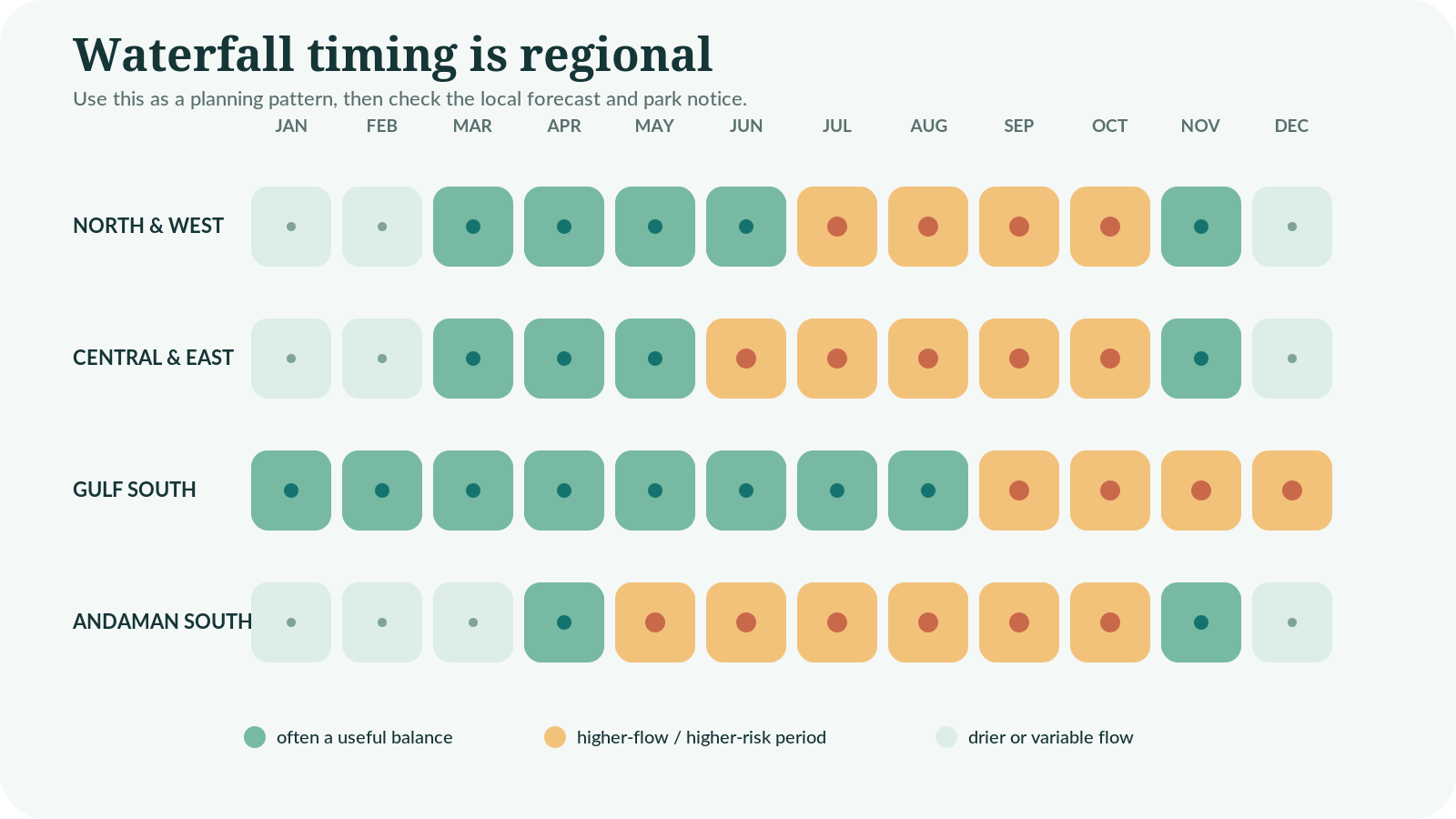
There is no single nationwide “waterfall season”. Northern and western routes, the Gulf side, the Andaman side and the eastern islands do not receive their heaviest rain at exactly the same time. Check the province-level forecast through the Thai Meteorological Department, then check the local park or sanctuary notice.
The useful middle ground
Early or middle parts of a wet period can bring greener forest and improving flow before prolonged rain makes roads, trails and pools unreliable. Conversely, the cool season can be comfortable for walking while some falls steadily lose volume. A modest-flow waterfall with an open trail is usually a better day than a spectacular cascade behind a closure.
| Condition | Likely advantage | Main limitation |
|---|---|---|
| Late dry spell | Clearer roads and easier walking | Weak flow, heat and shallow pools |
| First regular rains | Greener forest and improving water | Slippery surfaces and showers |
| Peak wet period | Powerful cascades | Closures, flash flow, mud and transport disruption |
| Cooler dry months | More comfortable walking | Flow can reduce as weeks pass |
| Immediately after heavy rain | Dramatic appearance | Highest current, debris and flash-flood concern |
Rain upstream is the hidden variable
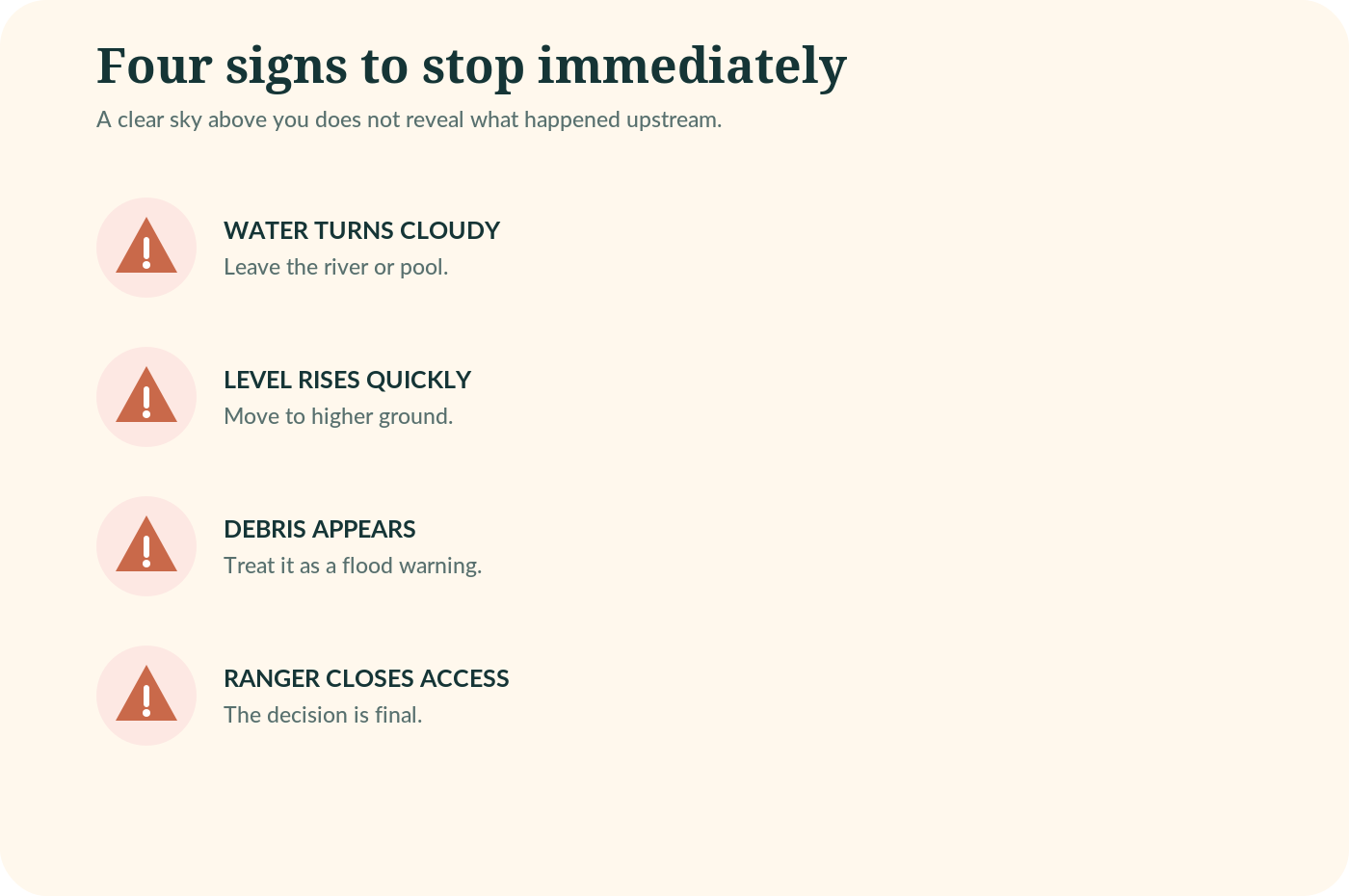
The sky above the car park does not tell you what happened higher in the catchment. Leave the water if it turns cloudy, rises quickly or begins carrying leaves and branches. Move away from the channel rather than standing nearby to film the change.
Closure means stop
A barrier, ranger instruction or closed-pool sign is not a suggestion. Do not climb around it for a photograph, and do not assume another visitor’s behaviour proves the area is safe.
Practical safety checklist
- Wear footwear that grips and stays attached to the foot.
- Keep children within immediate reach near moving water.
- Avoid alcohol before swimming, climbing or a forest walk.
- Never jump into water whose depth and hidden rocks are unknown.
- Do not stand beneath a heavy fall after rain.
- Turn back before the least confident person is exhausted.
- Keep a dry copy of identification and insurance details.
- Save the Tourist Police hotline, 1155, while you still have signal.
Leave the place quieter and cleaner
Carry out every item, keep soap and shampoo out of natural pools, do not feed wildlife and use changing areas respectfully. At Thi Lo Su and other protected landscapes, low-impact rules protect both wildlife and future access. Noise, litter and shortcuts beyond marked routes can cause real damage.
Connectivity is a backup, not a safety system
Download maps and park contacts before leaving town because signal can disappear. A Thailand eSIM may help with live updates where coverage exists, but it cannot replace a local check-in, a guide or a sensible turnaround time.
The best kit solves three ordinary problems: slipping, getting essentials wet and running out of water. Specialist equipment is rarely necessary for an easy attraction, while remote routes may require a local operator’s specific list.
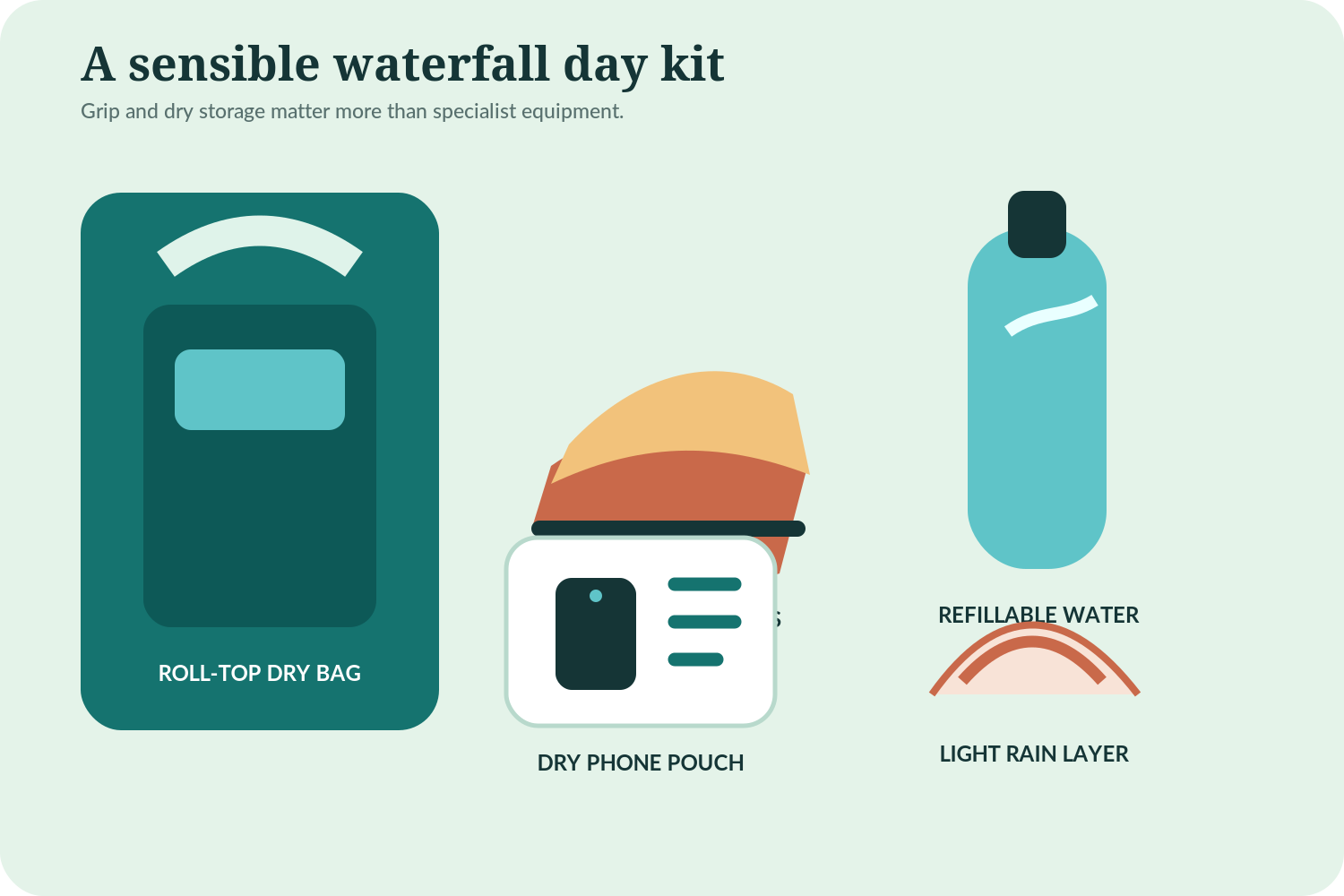
| Item | Best use | Buying or packing judgement |
|---|---|---|
| Breathable trail shoe | Long forest approaches | Prioritise grip, toe protection and a secure heel; accept that it may dry slowly. |
| Secure water shoe | Short wet approaches and designated pools | Choose a closed or firmly strapped design, not a loose slide or flip-flop. |
| Roll-top dry bag | Phone, spare clothes and documents | Useful for splashes, but not automatically waterproof when submerged. |
| Refillable water bottle | Every route | Carry more for humid climbs and do not rely on a remote kiosk being open. |
| Light rain layer | Mountain spray and showers | Choose ventilation over a heavy jacket in lowland humidity. |
| Quick-dry towel and spare layer | Swimming-permitted sites | Pack them in a separate dry compartment. |
| Small first-aid kit | Minor cuts and blisters | It does not make an unsafe route acceptable. |
Footwear decision
For Erawan’s longer route or higher Ton Nga Chang levels, choose trail support. For a short designated-pool visit, a secure water shoe can work. Loose flip-flops are poor trail footwear at every waterfall in this guide.
Why it can be one of the best days
- It adds forest, geology and cooler water to a temple, city or beach itinerary.
- Several choices fit established travel bases without a domestic flight.
- A multi-level site lets mixed groups adjust the walking distance.
- Early visits can provide quieter scenery and comfortable temperatures.
- The day can still work as a walk and viewpoint when swimming is closed.
Why it can become a poor choice
- Flow, visibility, access and swimming can change after rain.
- Long transfers are easily underestimated.
- Wet rock exposes weak footwear and rushed decisions.
- Popular sites become crowded on weekends and holidays.
- A famous photograph may represent a very different month.
Who should prioritise a waterfall
Active families, nature-focused couples, photographers and travellers building regional road trips gain the most. Anyone with limited mobility should check the precise final approach rather than relying on the word “easy”. Travellers on a compressed first-time itinerary should choose one route-matched waterfall rather than adding several distant options.
- Choosing only from peak-flow photographs.
- Assuming every attractive pool is open for swimming.
- Calling Khlong Plu on Koh Chang “Khlong Phrao Waterfall” and navigating to the wrong province.
- Attempting Thi Lo Su as a quick diversion.
- Wearing loose flip-flops on a wet forest trail.
- Arriving near midday without enough water or shade.
- Ignoring rain elsewhere in the catchment.
- Feeding fish or monkeys for a photograph.
- Climbing beyond a barrier or standing below a heavy fall.
- Putting a remote waterfall on the same day as a flight.
- Riding a scooter on wet roads without the correct licence, skill or insurance.
- Arguing with staff about a closure instead of using the backup plan.
The easiest fix
Build one alternative into the day: a museum or cafe in Kanchanaburi, another permitted Doi Inthanon stop, a Khao Yai viewpoint or a flexible Koh Chang beach afternoon. A backup converts a safety decision from a disappointment into a simple route change.
Choosing, timing and swimming
What is the best waterfall in Thailand?
Erawan is the best all-round first choice because it combines several levels, designated water areas when open and a practical Kanchanaburi base. Thi Lo Su is more dramatic and remote, but it requires a dedicated multi-day journey.
Which Thailand waterfall is easiest from Bangkok?
Wang Kan Lueang can work as a central road-trip day, while Haew Suwat belongs with Khao Yai and Erawan is better with an overnight Kanchanaburi stay. Traffic makes same-day estimates unreliable, so compare the whole route rather than straight-line distance.
Can you swim in Thailand waterfalls?
Some sites have designated pools, but permission can change with current, debris, depth, staffing and park rules. A photograph or old review does not prove swimming is allowed today.
What is the Sticky Waterfall near Chiang Mai?
Bua Tong is the limestone waterfall usually called the Sticky Waterfall. Its mineral surface provides more grip than ordinary slick rock, yet wet steps, algae, leaves and crowds still require care.
When is the best time to visit waterfalls in Thailand?
A useful-flow period after regular rain can balance green scenery and access, but the timing differs by region. Peak rain can close roads, trails and pools, while a long dry spell can reduce flow. Check the province forecast and the attraction notice close to travel.
Is Erawan suitable for children?
Lower levels can suit active families, provided adults keep children close and accept an early turnaround. The full route is longer and more slippery, so reaching every tier should never be the goal.
Access, fees and practical planning
How do you visit Thi Lo Su in 2026?
Plan a multi-day journey via Umphang and reconfirm the current sanctuary process with a reputable local operator or official contact. DNP announced reopening from 1 September 2026 after the annual closure, but later weather or conservation decisions can still change access.
Is Khlong Plu the same as Khlong Prao Waterfall?
Khlong Plu, also written Klong Plu or Khlong Phlu, is Koh Chang’s well-known west-coast waterfall near Khlong Prao. A different Khlong Phrao Waterfall exists in Chumphon, so use the Koh Chang name and map location carefully.
What shoes are best for Thailand waterfalls?
Choose breathable trail shoes for longer forest routes and secure water shoes for short wet approaches or designated pools. Avoid loose flip-flops because they offer little grip or foot protection.
How much are Thailand national park waterfall fees?
Fees differ by park, visitor category, attraction area and sometimes vehicle. The published DNP schedule lists 200 baht for a foreign adult at Namtok Phlio and Mu Ko Chang, while Khao Yai has entries between 200 and 400 baht. Recheck the exact gate before travel because the fee schedule and local arrangements can change.
Are waterfalls open during the rainy season?
Some are at their most impressive, while others close roads, trails or pools. DNP’s attraction dataset records site-specific closures, so never apply one park’s open status to another.
How many waterfalls should a two-week Thailand trip include?
For most first-time itineraries, one well-matched waterfall is enough. Choose the option that naturally fits Kanchanaburi, Chiang Mai, Khao Yai, Chanthaburi, Koh Chang or the south instead of spending days crossing the country for a checklist.
Choose Erawan for the strongest all-round first experience, provided you can start early from Kanchanaburi and accept that the upper route is optional. From Chiang Mai, pick Bua Tong for an active limestone day or Wachirathan for a lower-effort stop inside a full Doi Inthanon route. Haew Suwat is worthwhile when Khao Yai is already part of the trip, while Khlong Plu is the sensible forest contrast during a Koh Chang stay.
Save Thi Lo Su for a separate journey with current access information and enough time to respect Umphang’s logistics. The best waterfalls in Thailand are not the ones you force into the itinerary; they are the ones that fit the region, current conditions and the least confident person in the group.
The one decision to make now
Pick the travel base first. Then choose the waterfall, check the local notice within 24-48 hours of the outing and keep a dry-weather or closure alternative ready.
Research was checked on 10 September 2026. Opening times, fees, swimming permissions, road access and water conditions can change after publication. Official national information is a starting point; the local ranger, sanctuary or attraction notice on the day takes priority.
Current 2026 check
The DNP’s August 2026 notice announced that Thi Lo Su would reopen on 1 September 2026 after the annual wet-season closure and maintenance. The broader DNP attraction dataset also shows why travellers must check each site separately: closures and restricted activities are attraction-specific rather than national.
Official sources used
- Tourism Authority of Thailand – Beat the Heat: 5 waterfalls, 5 regions. Tourism Authority of Thailand; 4 June 2026. Bua Tong, Tad Ton, Wang Kan Lueang, Phlio and Ton Nga Chang descriptions.
- DNP notice on reopening Thi Lo Su Waterfall from 1 September 2026. Department of National Parks, Wildlife and Plant Conservation; 15 August 2026. Current 2026 reopening context and the need to obey wildlife-sanctuary rules.
- National park attraction opening and closure dataset. Department of National Parks, Wildlife and Plant Conservation; Catalog updated 27 January 2026. Site-specific and seasonal closure caveat.
- National park entrance fee dataset. Department of National Parks, Wildlife and Plant Conservation; Fee schedule dated 2 June 2023; catalog system updated 14 January 2026. Dated entrance-fee planning examples and recheck warning.
- Erawan Waterfall. Tourism Authority of Thailand; Accessed September 2026. Erawan attraction context.
- Mountain route and waterfalls at Doi Inthanon. Tourism Authority of Thailand; Accessed September 2026. Wachirathan as part of a wider Doi Inthanon day.
- Haew Suwat Waterfall. Tourism Authority of Thailand; Accessed September 2026. Haew Suwat attraction context.
- Khao Yai National Park. Tourism Authority of Thailand; Accessed September 2026. Khao Yai route context.
- Namtok Phlio National Park. Department of National Parks, Wildlife and Plant Conservation; Page last modified 23 September 2024; accessed September 2026. Distance from Chanthaburi and year-round flow context.
- Thai Meteorological Department. Thai Meteorological Department; Accessed September 2026. Province-level forecast recommendation.
- Tourist Police contact page. Thailand Tourist Police Bureau; Accessed September 2026. Tourist Police hotline 1155.
- Responsible Tourism. Tourism Authority of Thailand; Accessed September 2026. Low-impact nature guidance.
Illustrations in this article were created for Taylor’s Trailblazing Travels. Third-party photographs, where used, are credited beside the image or in the source list.